Atlas of the Basque Country

From Wikimedia Commons, the free media repository
(Redirected from Atlas of Basque Country)
Jump to navigation Jump to search
Wikimedia Commons Atlas of the World

The Wikimedia Atlas of the World is an organized and commented collection of geographical, political and historical maps available at Wikimedia Commons.
Discussion • Update the atlas • Index of the Atlas • Atlas in categories • Other atlases on line
The introductions of the country, dependency and region entries are in the native languages and in English. The other introductions are in English.
 
Basque Country


Euskal Herria

Español Euskal Herria

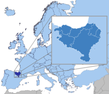
Euskal Herria (literalmente significa "país del euskera") es una denominación territorial documentada desde el siglo XVI. Abarca siete territorios históricos: Alta Navarra, Álava/Araba, Gipuzkoa, Bizkaia, Baja Navarra, Labort y Sola. Está aceptado por los investigadores de la cultura vasca como hecho cultural de forma amplia, y por los nacionalistas vascos como ente posible político, independiente en algunos casos, o en otros, con colaboraciones estables entre los territorios.

Euskara Euskal Herria

Euskal Herria Europako herrialdea da. Historikoki euskaldunen eta euskararen lurraldea da, Pirinio mendien mendebaldean kokatua, Frantzia eta Espainiaren arteko muga egiten duen mendilerroan, eta Bizkaiko golkorantz zabaltzen dena. Euskal Herriak 20.664 km²-ko azalera du, eta gutxi gorabehera 3.007.661 bizilagun.

Français Pays basque

Le Pays basque est un territoire qui s'étend à l'ouest des Pyrénées, au bord de l'océan Atlantique. Il couvre un peu plus de 20.664 km² où habitent environ 3 millions de personnes. Il se divise en trois entités : deux communautés autonomes d'Espagne, la Communauté autonome du Pays basque, composée des trois territoires historiques d'Alava, du Guipuscoa et de Biscaye, qui constitue plus de 70 % de la population totale, et la Navarre qui représente plus de 50 % du territoire, et le Pays basque français pour moins de 10 % de la population et 15 % du territoire.

English Basque Country -
The Basque Country as a cultural entity (not to be confused with the homonym autonomous community of the Basque Country) is a region in the western Pyrenees that spans the border between France and Spain, on the Atlantic coast. It comprises the Basque Autonomous Community and Navarre in Spain and the Northern Basque Country in France. It has not political entity. It roughly corresponds with the homeland of the Basque language and Basque traditions. As such, it is a concept mostly used within Basque nationalism.

Short name Basque Country
Official  name
Status Divided by France and Spain
Capital
Population 3,007,661 inhabitants
Area 20,664 km²
Major  languages Basque, Spanish, French
Major  religions Roman Catholicism
More information Basque Country, Geography of Basque Country, History of Basque Country and Politics of Basque Country
More  images Basque Country - Basque Country (Category).

General maps

Euskal Herriko mapa fisikoa
Mapa físico del País Vasco
Carte physique du Pays Basque
Physical map of the Basque Country
Euskaraz hitz egiten duten Euskal Herriko biztanleen ehunekoa
Porcentaje de población de habla vasca
Pourcentage de la population parlant basque
Percentage of Basque speaking population
Cultural identity. Do you consider yourself Basque?
1: Yes
2: Yes, in some ways
3: No
4: Don't known / Don't answer
Percentage of scholars registered in Basque language (2000-2005)

Notes and references

General remarks:

  • The WIKIMEDIA COMMONS Atlas of the World is an organized and commented collection of geographical, political and historical maps available at Wikimedia Commons. The main page is therefore the portal to maps and cartography on Wikimedia. That page contains links to entries by country, continent and by topic as well as general notes and references.
  • Every entry has an introduction section in English. If other languages are native and/or official in an entity, introductions in other languages are added in separate sections. The text of the introduction(s) is based on the content of the Wikipedia encyclopedia. For sources of the introduction see therefore the Wikipedia entries linked to. The same goes for the texts in the history sections.
  • Historical maps are included in the continent, country and dependency entries.
  • The status of various entities is disputed. See the content for the entities concerned.
  • The maps of former countries that are more or less continued by a present-day country or had a territory included in only one or two countries are included in the atlas of the present-day country. For example the Ottoman Empire can be found in the Atlas of Turkey.

Entries available in the atlas

General pages
World
Continents and oceans
Themes
Historical eras
States with wide recognition
States with limited recognition
Dependencies and other overseas territories
Subnational autonomous territories
Disputed subnational territories
Other regions
Former sovereign states
Former dependencies and overseas territories
Former disputed territories