The Cook Islands are a self-governing parliamentary democracy in free association with New Zealand. The 15 small islands in this South Pacific Ocean country have a total land area of 240 square kilometres (92.7 sq. mi). It has maritime borders with ► Niue, ► American Samoa, ► Tokelau, ► Kiribati and ► French Polynesia. Defence is the responsibility of New Zealand, in consultation with the Cook Islands and at its request. In recent times, the Cook Islands has adopted an increasingly independent foreign policy.
Ko ngā Kuki Airani he whenua i Te Moana-nui-a-Kiwa. I haere mai tēnei ingoa i te ingoa nō Kāpene Kuki. Ko Ipukarea tētahi atu ingoa nō taua whenua i te reo Māori Kuki Airani. Ko "te whenua tupu" te tikanga o tēnei kupu i te reo Māori nō Aotearoa.
Short name
Cook Islands
Official name
Cook Islands
Status
Country in free association with New Zealand since Associated state since 1965, New Zealandian since 1901
This section holds a short summary of the history of the area of present-day the Cook Islands, illustrated with maps, including historical maps of former countries and empires that included present-day the Cook Islands.
James Cook discovers in 1773 the Cook Islands (earlier seen by the Spanish explorer Álvaro de Mendaña) The islands become a British protectorate in 1888 and become a possession of New Zealand in 1901. In 1904 Niue island is separated from Cook to become a separate dependency.
Notes and references
General remarks:
The WIKIMEDIA COMMONS Atlas of the World is an organized and commented collection of geographical, political and historical maps available at Wikimedia Commons. The main page is therefore the portal to maps and cartography on Wikimedia. That page contains links to entries by country, continent and by topic as well as general notes and references.
Every entry has an introduction section in English. If other languages are native and/or official in an entity, introductions in other languages are added in separate sections. The text of the introduction(s) is based on the content of the Wikipedia encyclopedia. For sources of the introduction see therefore the Wikipedia entries linked to. The same goes for the texts in the history sections.
Historical maps are included in the continent, country and dependency entries.
The status of various entities is disputed. See the content for the entities concerned.
The maps of former countries that are more or less continued by a present-day country or had a territory included in only one or two countries are included in the atlas of the present-day country. For example the Ottoman Empire can be found in the Atlas of Turkey.


 Aitutaki Atoll
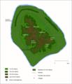 Atiu
Atiu Mangaia
 Manuae Atoll
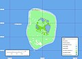 Mitiaro Island
 Nassau Island
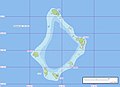 Palmerston Island
 Pukapuka Atoll
 Takutea Island


