File:1941-1943 Axis occupation of Yugoslavia map - en.svg
Jump to navigation
Jump to search

Size of this PNG preview of this SVG file: 657 × 599 pixels. Other resolutions: 263 × 240 pixels | 526 × 480 pixels | 842 × 768 pixels | 1,123 × 1,024 pixels | 2,246 × 2,048 pixels | 1,613 × 1,471 pixels.
Original file (SVG file, nominally 1,613 × 1,471 pixels, file size: 2.89 MB)
Captions
Captions
Add a one-line explanation of what this file represents
Summary
[edit]| Description |
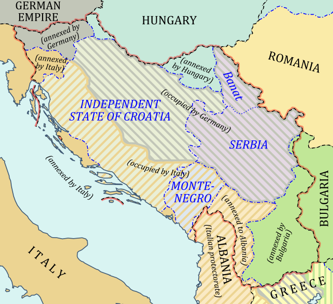
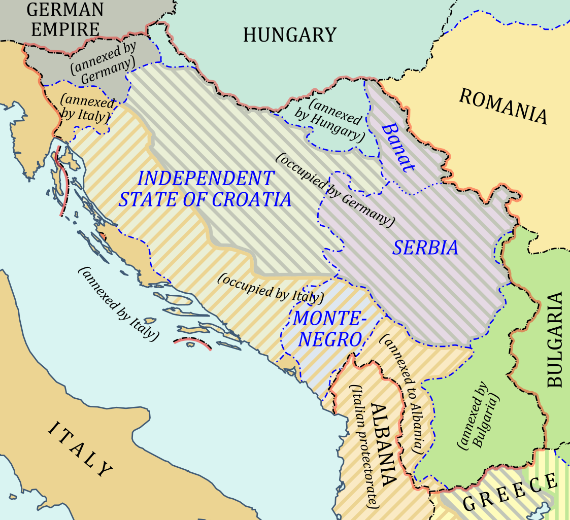
English: Map of Yugoslavia under Axis occupation in 1941-1943 (in English). Русский: Карта Югославии, оккупированной фашистской Германией и ее союзниками в 1941-1943 гг. (на английском языке). |
| Date | |
| Source | Own work |
| Author | Hellerick |
| Other versions |
[]
|


Licensing
[edit]
I, the copyright holder of this work, hereby publish it under the following license:
This file is licensed under the Creative Commons Attribution-Share Alike 3.0 Unported license.
- You are free:
- to share – to copy, distribute and transmit the work
- to remix – to adapt the work
- Under the following conditions:
- attribution – You must give appropriate credit, provide a link to the license, and indicate if changes were made. You may do so in any reasonable manner, but not in any way that suggests the licensor endorses you or your use.
- share alike – If you remix, transform, or build upon the material, you must distribute your contributions under the same or compatible license as the original.
File history
Click on a date/time to view the file as it appeared at that time.
| Date/Time | Thumbnail | Dimensions | User | Comment | |
|---|---|---|---|---|---|
| current | 07:20, 17 February 2014 | | 1,613 × 1,471 (2.89 MB) | Hellerick (talk | contribs) | Krk annexed by Italy. |
| 16:32, 12 February 2014 |  | 1,613 × 1,471 (2.9 MB) | Hellerick (talk | contribs) | oops, wrong language | |
| 02:36, 12 February 2014 |  | 1,613 × 1,471 (2.9 MB) | Hellerick (talk | contribs) | + maritime boundaries | |
| 04:19, 31 July 2013 |  | 1,613 × 1,471 (984 KB) | Hellerick (talk | contribs) | More contrast | |
| 05:29, 30 July 2013 |  | 1,613 × 1,471 (923 KB) | Hellerick (talk | contribs) | Part of Greece annexed by Italy. | |
| 04:50, 30 July 2013 |  | 1,613 × 1,471 (922 KB) | Hellerick (talk | contribs) | User created page with UploadWizard |
You cannot overwrite this file.
File usage on Commons
The following 15 pages use this file:
- Atlas of Yugoslavia
- User:Hellerick/1941-1943 Axis occupation of Yugoslavia maps
- File:1941-1943 Axis occupation of Yugoslavia map-hu.svg
- File:1941-1943 Axis occupation of Yugoslavia map.svg
- File:1941-1943 Axis occupation of Yugoslavia map - en.svg
- File:1941-1943 Axis occupation of Yugoslavia map - es.svg
- File:1941-1943 Axis occupation of Yugoslavia map - hr.svg
- File:1941-1943 Axis occupation of Yugoslavia map - ru.svg
- File:1941-1943 Axis occupation of Yugoslavia map - sr.svg
- File:2차 대전 기간 알바니아의 지도.png
- File:Map of Albania during WWII-CS.png
- File:Map of Albania during WWII-IT.png
- File:Map of Albania during WWII.png
- File:Map of Albania during Worl War 2.png
- Template:Other versions/Map of Albania during WWII
File usage on other wikis
The following other wikis use this file:
- Usage on bg.wikipedia.org
- Usage on en.wikipedia.org
- Usage on fa.wikipedia.org
- Usage on ka.wikipedia.org
- Usage on pl.wikipedia.org
- Usage on zh.wikipedia.org