File:Black Sea map-de.png
Jump to navigation
Jump to search
Size of this preview: 786 × 599 pixels. Other resolutions: 315 × 240 pixels | 630 × 480 pixels | 1,007 × 768 pixels | 1,200 × 915 pixels.
Original file (1,200 × 915 pixels, file size: 237 KB, MIME type: image/png)
Captions
Captions
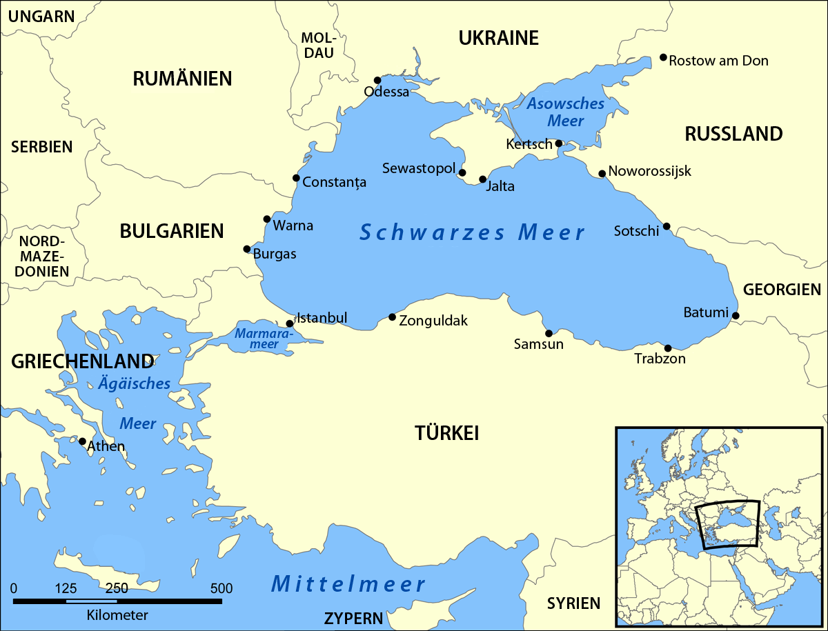
Map of the Black Sea
| Description |
Deutsch: Karte des Schwarzen Meeres
English: Map of the Black Sea |
| Date | (UTC) |
| Source | |
| Author |
|
| Other versions |
[]
|


.png)


| This is a retouched picture, which means that it has been digitally altered from its original version. Modifications: translation. The original can be viewed here: Black Sea map.png:
|
This file is licensed under the Creative Commons Attribution-Share Alike 3.0 Unported license.
- You are free:
- to share – to copy, distribute and transmit the work
- to remix – to adapt the work
- Under the following conditions:
- attribution – You must give appropriate credit, provide a link to the license, and indicate if changes were made. You may do so in any reasonable manner, but not in any way that suggests the licensor endorses you or your use.
- share alike – If you remix, transform, or build upon the material, you must distribute your contributions under the same or compatible license as the original.
Original upload log
[edit]
This image is a derivative work of the following images:
- File:Black_Sea_map.png licensed with Cc-by-sa-3.0-migrated, GFDL
- 2007-07-10T18:10:36Z NormanEinstein 1200x915 (382990 Bytes) Updated maps to add Russian city of Sochi.
- 2007-05-07T19:11:11Z NormanEinstein 1200x912 (378400 Bytes) Corrected city name typo.
- 2006-05-29T13:10:42Z NormanEinstein 1200x914 (136455 Bytes) Reduced image size.
- 2005-07-25T14:54:05Z NormanEinstein 1200x916 (487643 Bytes) A map showing the location of the Black Sea and some of the large or prominent ports around it. The Sea of Azov and Sea of Maramara are also labelled. Created by NormanEinstein, July 25, 2005. {{GFDL-self}} [[Category:Maps
Uploaded with derivativeFX
File history
Click on a date/time to view the file as it appeared at that time.
| Date/Time | Thumbnail | Dimensions | User | Comment | |
|---|---|---|---|---|---|
| current | 11:33, 12 April 2011 | | 1,200 × 915 (237 KB) | NordNordWest (talk | contribs) | c |
| 19:49, 11 April 2011 |  | 1,200 × 915 (237 KB) | NordNordWest (talk | contribs) | {{Information |Description={{de|Karte des Schwarzen Meeres}} {{en|Map of the Black Sea}} |Source=*File:Black_Sea_map.png |Date=2011-04-11 19:47 (UTC) |Author=*File:Black_Sea_map.png: Created by User:NormanEinstein *derivative work: ~~~ |Pe |
You cannot overwrite this file.
File usage on Commons
The following 18 pages use this file:
- File:Black Sea map-ar.png
- File:Black Sea map-de.png
- File:Black Sea map-sv.png
- File:Black Sea map-tr.png
- File:Black Sea map-zh.png
- File:Black Sea map.png
- File:Black Sea map blank.png
- File:Black Sea map he.png
- File:Black Sea map he (cropped).png
- File:Black Sea map hr.svg
- File:Black Sea map ku.png
- File:Black Sea map lld.png
- File:Black Sea map ta.png
- File:Mer Noire (carte).png
- File:Morze Czarne mapa pl.png
- File:Zwarte Zee.png
- File:ΜαύρηΘάλασσα.PNG
- Template:Other versions/Black Sea map
.png)
File usage on other wikis
The following other wikis use this file:
- Usage on ar.wikipedia.org
- Usage on az.wiktionary.org
- Usage on de.wikipedia.org
- Usage on frr.wikipedia.org
- Usage on lb.wikipedia.org
- Usage on stq.wikipedia.org