File:MTAB IORE Søsterbekk - Norddalen.jpg
Jump to navigation
Jump to search

Size of this preview: 800 × 494 pixels. Other resolutions: 320 × 198 pixels | 640 × 395 pixels | 1,024 × 632 pixels | 1,280 × 790 pixels | 2,560 × 1,580 pixels | 6,094 × 3,762 pixels.
Original file (6,094 × 3,762 pixels, file size: 6.04 MB, MIME type: image/jpeg)
Captions
Captions
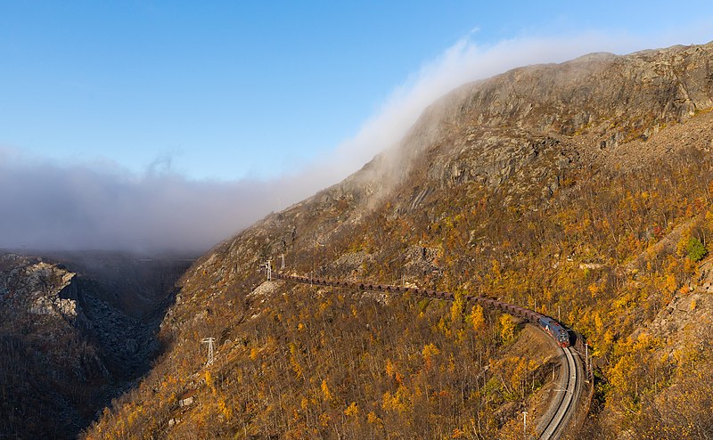
A pair of MTAB IORE locomotives haul a loaded iron ore train towards Narvik
Summary
[edit]
| Description |
English: A pair of Malmtrafik i Kiruna AB IORE locomotives (109 leading with an unidentified second unit) haul a loaded iron ore train towards Narvik. Pictured between Søsterbekk and Norddalen, Norway. The old Norddalen viaduct can be seen in the background.
Ab: Ein Paar IORE-Lokomotiven (109 und eine unidentifizierte zweite Maschine) der Malmtrafik i Kiruna AB zieht einen beladenen Erzzug nach Narvik. Aufgenommen zwischen Søsterbekk und Norddalen, Norwegen. Das alte Norddalen-Viadukt ist im Hintergrund zu erkennen. |
| Date | |
| Source | Own work, also available at https://bahnbilder.ch/picture/27905 |
| Author | Kabelleger / David Gubler |
| Other versions |
| Camera location | | View this and other nearby images on: OpenStreetMap |
|---|
Assessment
[edit]
|
Licensing
[edit]
I, the copyright holder of this work, hereby publish it under the following license:
This file is licensed under the Creative Commons Attribution-Share Alike 4.0 International license.
- You are free:
- to share – to copy, distribute and transmit the work
- to remix – to adapt the work
- Under the following conditions:
- attribution – You must give appropriate credit, provide a link to the license, and indicate if changes were made. You may do so in any reasonable manner, but not in any way that suggests the licensor endorses you or your use.
- share alike – If you remix, transform, or build upon the material, you must distribute your contributions under the same or compatible license as the original.
File history
Click on a date/time to view the file as it appeared at that time.
| Date/Time | Thumbnail | Dimensions | User | Comment | |
|---|---|---|---|---|---|
| current | 19:18, 28 May 2021 | | 6,094 × 3,762 (6.04 MB) | Kabelleger (talk | contribs) | Uploaded own work with UploadWizard |
You cannot overwrite this file.
File usage on Commons
The following 14 pages use this file:
- User:Meiræ/21
- User talk:Iifar/FP promotions from other authors
- Commons:Featured picture candidates/File:MTAB IORE Søsterbekk - Norddalen.jpg
- Commons:Featured picture candidates/Log/June 2021
- Commons:Featured pictures/Objects/Vehicles/Land vehicles
- Commons:Featured pictures/chronological/2021-A
- Commons:Featured pictures/chronological/June 2021
- Commons:Picture of the Year/2021/Candidates
- Commons:Picture of the Year/2021/R1/Gallery/2021-A
- Commons:Picture of the Year/2021/R1/Gallery/ALL
- Commons:Picture of the Year/2021/R1/Gallery/M06
- Commons:Picture of the Year/2021/R1/Gallery/Vehicles and crafts
- Commons:Picture of the Year/2021/R1/v/MTAB IORE Søsterbekk - Norddalen.jpg
- File:MTAB IORE Søsterbekk Norddalen Wikivoyage banner.jpg
File usage on other wikis
The following other wikis use this file:
- Usage on fr.wikipedia.org